
www.rambler-info.org.uk - estimating Altitudes with a GPS
The Global Positioning System [GPS] was set up to give accurate horizontal readings. The vertical readings have something around 1.6 times the error of the horizontal readings. Yet our needs for vertical accuracy are generally more stringent than our horizontal requirements! Being above a 20m high cliff could be serious, whilst being 20m out on our horizontal position is a non-event!
To get better accuracy, some GPS units have a built-in aneroid altimeter. Whilst I have seen manufacturers claim 5m accuracy for their units, I was always taught that aircraft altimeters could be trusted only to detect 10m changes.
Had you taken in that I said "detect" in the last paragraph? Whilst the aneroid barometer will track one's vertical movements well, it is profoundly affected by the weather. I need to check the figures, but my memories of pre-take-off checks in aircraft is that one often had to reset the altimeter's 1013.2mb standard setting by some 40mb either way during "good flying weather". The range of ±40mb is roughly the height of Ben Nevis (the UK's tallest mountain).
When I do a circular walk of several hours duration my Garmin eTrex Summit will give me a trace showing every little hump and hollow and yet the start and finish heights are different. Part of the reason is that the atmospheric pressure has changed due to moving weather systems.
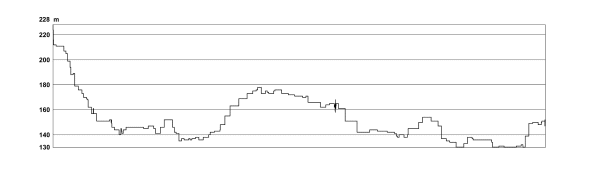
In the example above, the start and finish points are the same. However, they show a 50m height difference due to a change in the weather. [Perceptive readers, who have already skewed the graph in their imaginations, will have already realised that the walk was in flat country and the actual height variation was significantly less than the 80m range of the graph.]
In the Alps, or any other big mountains, an error of 50m in searching for the correct side-ridge off of a mountain while in cloud could be a very serious matter.
We can now see that the GPS height is inaccurate and the aneroid height is more precise, but has an unknown calibration.
Well, I suppose I could keep well away from mountains during my walks.
Alternatively, I can try and anticipate the need for accurate height readings and arrange to visit a point of know height on the way to the critical place. By that I mean, perhaps, identify a col or summit that is marked with its height on the map and include it on my route. If my GPS is then given a "user calibration" at that point, I can then use it in the near future to get accurate heights.
 The Garmin eTrex Summit offers an "auto-calibrate" mode for altitude. This means that the instrument will compare the "satellite altitude" with the "aneroid altitude" and thus calibrate the aneroid readings (the display always reads from the aneroid). Rumour has it that this mode takes about 30 min to complete its action, as it will need to take averages over a good number of readings. [My own tests show that autocalibrate is still homing-in up to 2 hours]
The example in the graph above was a trace with the auto-calibrate facility switched on and the walk began immediately after switching on the GPS. If you ignore the first 30 min, which is about 20% of the distance axis, then the trace begins to look surprisingly accurate when carefully compared with the contours of the OS map. For the record, the trace starts and finishes at about 148m, the maximum is about 169m and the minimum about 110m. (Perhaps I should add that the GPS on my rucksack was about 1.5m above the ground!)
![]()
![]()