
www.rambler-info.org.uk - tests on the auto-calibrate feature
I read somewhere that the eTrex Summit takes 20min for the auto-calibrate function to work.
Interesting! So I did some tests and here are the results.
I had not got round to thinking how auto-calibrate works, but then I started to wonder how it is done.
Presumably a good method is to collect differences between the erratic GPS altitudes and the precise but weather-affected aneroid altitudes. The aneroid readings should lie at the mid-point of the band of GPS values. Apply a suitable compensation to the aneroid values then use them for following changes of altitude, while continuing to monitor the level of compensation needed.
This should work, provided the process is sluggish enough to avoid the GPS results causing short-term fluctuations ...but how sluggish?
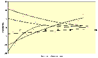 To find out what tactics Garmin are using, I sat my eTrex Summit in the garden and watched the readings over some time. Then I did it again, and again. The results were interesting, but a bit hard to follow due to scatter, so I applied a curve-fitting routine to get the simpler shapes for the curves.
Of the five curves, four look very impressive but surprisingly slow to settle. The fifth curve does not settle and presumably could not cope with a fairly rapid change of barometric pressure during the test (the synoptic chart for the day confirms this was so, but I have no detailed figures)
I will now treat my Summit with greater respect. The altitude compensation is much better than I expected, but I must try to get the GPS running some time before our walks commence if I want serious altitude traces.
Added later. I now have a standard practice of setting the altitude manually at the start of a walk, assuming I am able to get it from the map. Afterwards I do the walk leaving the eTrex Summit left on auto-calibrate. I now get traces which have the same altitude ±5m when I get back to the start of the walk.
 1) What sort of accuracy might one expect after the settling-down stage is passed? The GPS is quite obliging here: just leave it in one place for a long time and then see what the altitude vs. time trace looks like. I tried this over a 9½hr period. The result was good, the altitude staying within a ±5m band the whole time and being well within it for the majority of the time.
2) Do the "Normal" and "Economy" modes have different times for the trace to settle? I have done some tests. Bearing in mind that the "setting-down" curves are very variable, I would not claim to definitely have seen an improvement.
![]()
![]()