
www.rambler-info.org.uk - some typical GPS tracks
A useful example for those without access to digital maps.
They show how true an everyday GPS track might be.
The GPS used was a Garmin® Geko201 running in "Battery Save" mode and mounted on the shoulder strap of a rucksack.
The background maps are acknowledged to Ordnance Survey 1:25000 series and Memory Map®.
The scale is given by the blue 1km squares in the images.
A section recorded under difficult conditions
The GPS track is red
A steep hillside interrupts satellite signals, as do dense tall woodlands and a sunken road.
There are already signs of trouble at the top of the picture, with a false reading on the open hillside.
Things become worse on the road adjacent to the woodlands.
Then some big errors as the path rises steeply through Sheepwalk Wood.
The yellow-coloured road will be at least 4m wide, but it is slightly recessed into the hillside and surrounded by trees.
South of Lees Road there might be a systematic error of some sort: the track appears to be displaced about 17m from the path.
A typical section
The GPS track is red
Moderate slopes but no woodlands make for fairly good conditions.
See the yellow road near the top of the image. We walked NNE along it, initially on the left, but crossed it soon after the river. Full marks!
The trace does not always follow the green ROW lines, but neither did the most-used footpath.
In particular, the track near the bottom of the image follows the currently-used path and not the green ROW.
Mostly flat terrain and some light wooded areas
The GPS track is red
Only slight deviations from the paths.
The biggest error is around the disused railway cutting to the North of the Haddon Park label. Error is quite small.
Click here to see same walk recorded with a newer Garmin model
Sloping terrain, lightly wooded areas and a village.
The GPS track is red
A good result with accuracy good and only a few slight errors.
The transit of the village contains 2 and 4 storey buildings. No problems.
Systematic errors with an example.
The GPS track is composed of blue circles - each is an individual reading
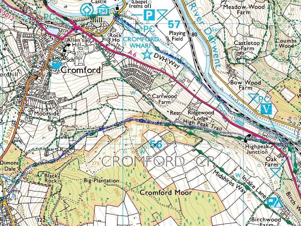
If you look in the lower right area there are systematic errors while the GPS
was carried down the straight sections of the inclined plane on the High Peak Trail.
The errors are all to the north and cease once that section of the walk is completed.
I have plenty of ideas about why the GPS has got its distance from the satellites wrong, but I will be honest and admit that I don't know.
Such systematic errors do occur from time to time and the GPS user should be aware that such things are possible!
Should one be relying on a GPS in the terrain shown below?
The GPS track is red
There are two areas here where one would not really expect a GPS to function.
1...The tangled track at Birchover is the result of exploring a hill topped with overhanging rocks. A tunnel through the rocks was traversed twice!
Back on the half-sunken path beside Birchover church the results are slightly erratic on the part-wooded hillside but quite acceptable.
2...The section between Robin Hoods Stride and Hermits Cave traverses a wooded hillside on paths that fall just short of scrambling in places.
The outward and return paths were identical, but this is not reflected by the track.
Near the cave at the foot of an overhanging cliff, there is one point showing a gross error to the SSW which I estimate at 145m...
...However, it is impressive that the GPS works at all in these conditions.
How authentic are these tracks?
I have a lot of stored tracks.
When I wrote this Web page I used this set of data since the walk was fresh in my mind (48hrs before) and our route covered a good variety of terrain.
There were no other factors in my choice and when I look at the images above they are pretty much as I would have expected.